
Why does Velachery flood?
Encroachment and broken governance around Velachery Lake amplify flooding, exposing the cost of ignoring catchment-based planning.
Thisai
May 2025
Making of a Flood-Prone Neighbourhood in Chennai Urban Expansion and the Loss of Permeability

Flooding in Velachery, a southern neighbourhood of Chennai, is often framed as a consequence of extreme rainfall or inadequate municipal response. However, a closer examination reveals that Velachery’s vulnerability to flooding is neither incidental nor inevitable. Instead, it is the cumulative outcome of decades of urban expansion, ecological transformation, and planning decisions that have systematically altered the region’s natural hydrology. The case of Velachery exemplifies how cities, when developed without regard for ecological systems, create their own disasters.
Velachery’s transformation accelerated particularly after the 1970s and 1980s, as Chennai’s population grew and the city expanded southward. Survey of India maps from the 1970s depict Velachery as a landscape marked by lakes, grazing land, and sparse settlement. Over time, these permeable surfaces were replaced by roads, apartment complexes, IT parks, and commercial developments. This shift fundamentally altered the area’s hydrology. Concrete and asphalt drastically reduce the land’s ability to absorb water, increasing surface runoff and overwhelming drainage systems. High-rise developments and gated communities often emerged without adequate stormwater infrastructure, placing additional pressure on already compromised waterways. In this context, flooding becomes not a failure of nature but a predictable outcome of impermeable urban form.
Velachery’s Ecological Context, Shrinking Water Bodies and Encroachment
Velachery lies at the southern edge of the Chennai Metropolitan Area (CMA), a location that historically placed it within a network of lakes, wetlands, and grazing lands that played a critical role in flood moderation. Much of the land surrounding Velachery and neighbouring areas such as Adambakkam was classified as meikal poromboke or common grazing land. These landscapes were not “empty” or “unused,” as later colonial planning narratives would suggest, but multifunctional commons that supported livelihoods, biodiversity, and hydrological balance. Wetlands and grazing lands act as natural sponges, absorbing monsoon rainfall, slowing surface runoff, and allowing water to percolate into the ground. In Velachery’s case, these landscapes were integral to floodwater management and groundwater recharge. Their presence ensured that excess rainwater was dispersed and stored rather than channelled rapidly into low-lying residential areas.


From top left to right: Vintage image captures the early construction phase of the Velachery flyover | Source: Rakesh Ashok; Extent of Velachery Eri as mapped in 1970 | Source: Survey of India, 1970; Current extent of velachery Eri; Ariel view of the Velachery lake, captured by photgrapher Raj Mohan, 2020
One of the most striking indicators of ecological loss in Velachery is the dramatic shrinkage of Velachery Lake itself. Historical records show that the lake once covered approximately 265 acres. Today, it has been reduced to less than 55 acres due to illegal encroachments, land reclamation, and unregulated construction. This reduction has significantly diminished the lake’s capacity to store floodwaters during the monsoon and recharge groundwater during drier months. Encroachments along the lake’s banks, often informal settlements lacking basic sanitation infrastructure, have further exacerbated the problem. Direct discharge of sewage into the lake has increased nutrient loads, depleted oxygen levels, and degraded water quality, undermining the lake’s ecological function. What was once a living water body capable of self-regulation has increasingly become a stagnant basin overwhelmed during periods of heavy rainfall.
Issues of Velachery Lake: Informal Encroachments, Drainage Failures, Blocked Waterways and Environmental degradation
Velachery’s stormwater drainage system reflects decades of piecemeal and reactive planning. Many drains are outdated, undersized, or poorly maintained, making them incapable of handling intense monsoon rainfall. In several areas, drains are clogged with solid waste or sewage, causing water to stagnate rather than flow. Compounding this issue is the blockage of natural watercourses. Historically, channels from areas such as Pallikaranai Marsh allowed water to flow freely into Velachery Lake and other downstream systems. Roads, buildings, and encroachments have since obstructed these pathways, forcing floodwaters to spill into streets and homes instead of draining naturally. As a result, Velachery’s roads routinely transform into waterways during the monsoon, highlighting the cost of disregarding natural drainage patterns.
Flooding in Velachery is not merely an inconvenience; it is closely linked to environmental and public health concerns. Polluted floodwaters often contain untreated sewage and industrial waste, increasing the risk of waterborne diseases. Reports have documented high levels of bacteria and chlorides in Velachery Lake, underscoring the severity of contamination. Moreover, the degradation of wetlands and lakes reduces urban resilience to climate variability. The Living Planet Report (2024) notes a significant decline in Chennai’s wetland areas due to rapid urbanisation, weakening the city’s ability to cope with both floods and droughts. In Velachery, this paradox is evident: the neighbourhood experiences severe flooding during the monsoon and water scarcity during dry seasons.
Governance Gaps and Unfulfilled Promises


Image: Timeline depecting the "proposals that remain on paper", Graphic credits: Author
Despite repeated recognition of Velachery Lake’s importance, restoration efforts have often remained fragmented or unfulfilled. Over the past decade, multiple proposals ranging from walkways and boating facilities to comprehensive lake rejuvenation, have been announced, delayed, or partially implemented. Encroachments continue to persist, and enforcement remains inconsistent. Recent interventions by institutions such as the National Green Tribunal (NGT) have brought renewed attention to the issue, including concerns over lake pollution and surrounding development. However, long-term solutions require more than isolated projects; they demand systemic change in how urban land, water bodies, and commons are governed.
Rethinking Urban Growth: A Choice for the Future
Velachery’s story reflects a broader pattern seen across Indian cities, where rapid urbanisation prioritises short-term growth over ecological sustainability. The framing of wetlands, grazing lands, and lakes as “vacant” land has enabled their conversion into real estate, often without accounting for the environmental services they provide. This approach externalises ecological costs, which later manifest as flooding, infrastructure damage, and public health crises.
Balancing growth with sustainability requires a fundamental shift in planning philosophy. Protecting and restoring water bodies, enforcing building regulations, upgrading drainage systems, and recognising the value of urban commons are essential steps. Equally important is community engagement, ensuring that local knowledge and lived experiences inform planning decisions. Following severe flooding in Velachery, residents proposed a 4D strategy- Deflect, Drain, Desilt, and Deepen to restore the lake in 2024. The plan includes diverting sewage with sluice gates and interceptors to treatment systems followed by desilting and deepening the lake. A GIS analysis by consultant Dayanand Krishnan highlighted obstructed drains, encroachments on nearby Ullagaram lake, and blocked natural outflows worsened flooding across surrounding neighbourhoods.
Velachery’s flooding is not simply a consequence of heavy rainfall; it is the result of deliberate choices made over decades. Choices to build over wetlands, to narrow lakes, to block water channels, and to treat natural systems as expendable. Yet, this trajectory is not irreversible. Velachery can either continue to drown under the weight of neglect or emerge as a model for resilient urban planning—one that integrates ecological restoration with development. As climate change intensifies monsoon patterns and urban populations grow, the lessons from Velachery become increasingly urgent. The future of Chennai’s neighbourhoods depends on whether cities choose to work with their landscapes rather than against them.


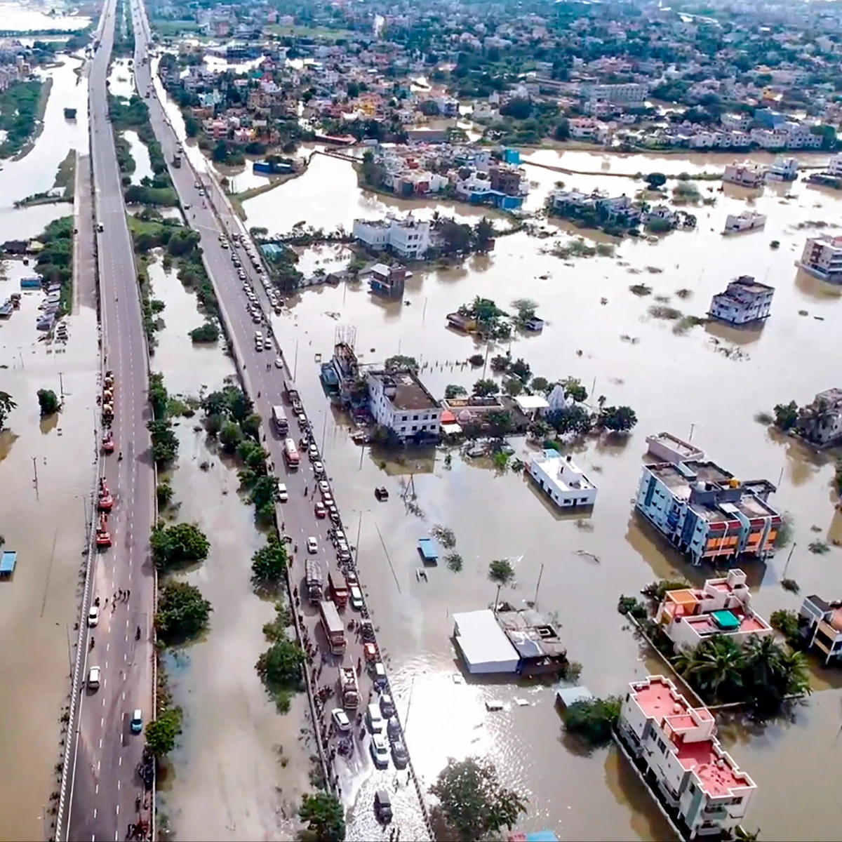


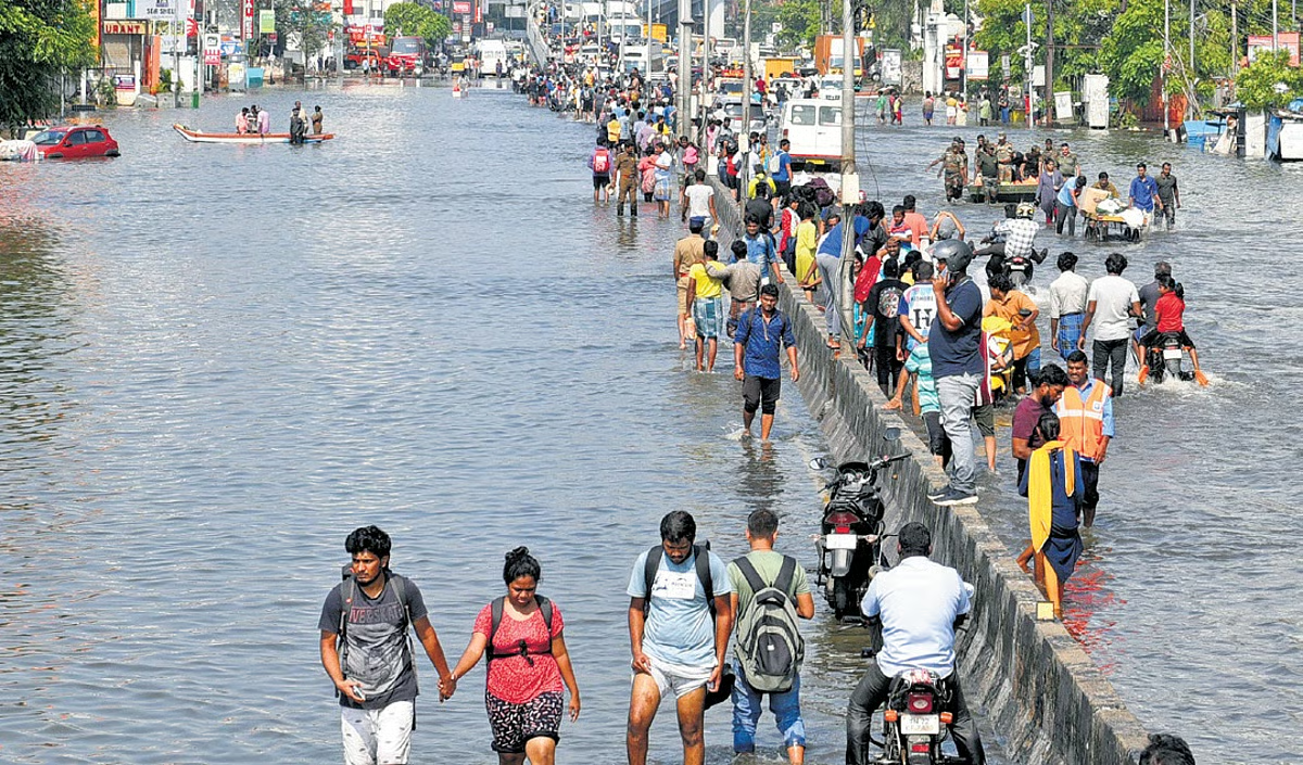
From top to bottom: People travel on a boat as they move to safer places through a flooded road in Chennai, December 2, 2015 | Source: REUTERS/Stringer; A drone visual shows an area that is flooded after the landfall of Cyclone Michaung | Source: PTI; People; Residents push a stranded car through flooded city streets | Source: Balu via Flicker; People wading through flood waters | Source: The New Indian Express
Velachery's story doesn't have to be one of sinking streets and lost landscapes - it can be a testament to resilience and smarter urban planning. Imagine a Velachery where rainwater doesn't choke the city but replenishes its lakes, where wetlands thrive alongside high-rises, and where floodwaters drain effortlessly instead of turning roads into rivers. This isn't wishful thinking, it's the future we must build. Restoring water bodies, enforcing stricter building regulations, revamping drainage systems, and integrating nature into the urban fabric can transform Velachery from flood-prone sprawl into a model of sustainable development.
Every monsoon serves as a warning - Velachery can either continue drowning in neglect or rise as a city that values its past while planning for a future that is both liveable and resilient.